Why LiDAR should be part of your aerial surveying solution
When it comes to aerial mapping and surveying, LiDAR and Photogrammetry are primary alternatives used to generate the required data. Photogrammetry has been the ‘go to’ solution for aerial surveying since the early 1900’s. This method provides photo-based 3D models and orthorectified imagery that is highly accurate, despite the simple mathematical principles it is based on.
LiDAR technology, on the other hand, began in the 1960s, with laser based remote sensing developed by NASA during the 70s. The technology has advanced considerably since its inception. LiDAR can now deliver a superior amount of data points compared to Photogrammetry.
Up until recently, Photogrammetry has been the most cost-effective solution. However, drone LiDAR technology is now becoming increasingly more competitive in pricing. With both technologies providing fast, high data density, the selection of the best technology really comes down to your project, environmental conditions and timeframes.
What is LiDAR?
LiDAR is short for Light Detection and Ranging, and can produce millions of 3D points per second. LiDAR has point densities as high as 10,000 points per square metre. Through sending and receiving reflected laser pulses, this technology can calculate distances extremely accurately, and reconstruct a 3D point-based model of the terrain.
Due to its accuracy and the ability to penetrate vegetation, LiDAR is extremely useful for gathering the data required in heavily vegetated areas. It is also used for modelling narrow objects such as powerlines or telecommunication infrastructure. On top of that, it can also work in poor natural lighting conditions, as the laser pulses are actively generated by the LiDAR sensor itself (they are active sensors).
How is LiDAR different to Photogrammetry?
LiDAR measures the time it takes for a laser pulse to return back to the sensor. Whereas, Photogrammetry is based on actual visible key points in multiple images that are triangulated to create 3D models. This dependence on light means that Photogrammetry is limited by only being able to capture data in areas that are illuminated (Photogrammetry sensors are passive).
A LiDAR survey will provide you with higher elevation accuracy and shorter processing times. In addition, as LiDAR doesn’t use a camera, there is no need to calibrate settings like you would for a Photogrammetry sensor (lens focus, white balance, ISO etc).
Due to the different technologies, both LiDAR and Photogrammetry have their use cases. If you are trying to decide between the two, perhaps the question needs to be, ‘what am I using it for?’.
LiDAR is particularly useful for highly accurate aerial surveying, mining and geology and forestry management. Whereas Photogrammetry is useful to track project changes, surveillance and agriculture.
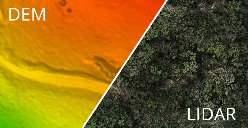
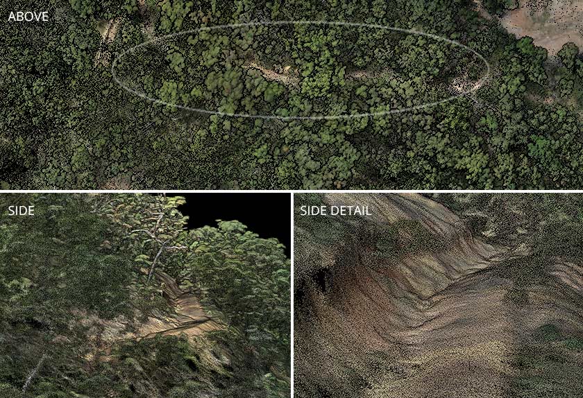
Exploring the LiDAR point cloud
The short video below is taken from a screenshot while exploring the point cloud generated from a LiDAR survey. In this scenario, the ability to view the ground surface beneath vegetation is a significant benefit. A Digital Elevation Model (DEM) derived from a LiDAR survey in this environment would obtain a much more effective (DEM) than a photogrammetry survey.
What are the outputs of LiDAR?
There are a number of outputs LiDAR can generate:
Vegetation Structures
Sometimes a laser pulse can generate multiple returns. Rather than going straight to the ground and back to the sensor, the light can hit different “obstacles” along the way and generate different returns. This is useful for determining the forest structure and shape of trees for example.
Topographic Models
If you’re looking to create a digital elevation model, LiDAR technology will help you measure any slopes, their direction and heights, with greater vertical accuracy compared to Photogrammetry.
Asset Inspection and Documentation
Data generated through LiDAR technology is combined with GPS metadata to create a detailed representation of an area of interest. That can be a valuable tool for asset inspection (road condition, bridges, powerlines etc.) and documentation purposes.
Canopy Height Models
By subtracting the last pulse return from the first pulse return measurements, you will be able to create high-resolution vegetation height models. This will work regardless of how complex the actual terrain is under the canopies.
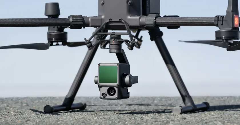
Our recommended LiDAR solution – DJI Zenmuse L1
The DJI Zenmuse L1 is a versatile mapping solution that can scan generate up to 480,000 points per second (in multiple return mode), with positional accuracy of 10 cm (horizontal) and 5 cm (vertical) flying at 50m. It also integrates a 20MP survey grade camera with a 1-inch CMOS, for point cloud colourisation and even data collection for classic photogrammetric workflows.
The L1 unlocks enhanced 3D survey capabilities when used with the DJI Matrice 300 RTK and DJI Terra. It quickly captures the finer details of complex structures and produces precisely reconstructed models at a centimetre accurate level.
Applications for the Zenmuse L1
The point cloud data obtained by the L1 provides the accurate details you need for elevation models, narrow objects and heavy vegetation. Using the point cloud data processing software DJI Terra, you can clearly see key elements such houses, roads and trees.
Classifying point cloud data allows us to distinguish between different types of features, such as buildings, trees, and terrain. This information can be used to generate digital elevation models.
The L1 provides unparalleled, centimetre accurate reconstructions due to its precise IMU, vision sensor and the incorporation of GNSS data. This makes the LiDAR sensor perfect for asset inspections involving bridges, powerlines and towers.