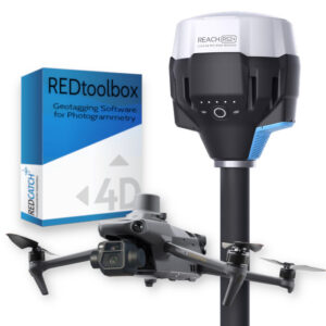
Standard Photogrammetry Survey Kit
From: $12,510.00
Combine the DJI Phantom 4 RTK and the Emlid Reach RS2+ GNSS RTK receiver to implement photogrammetry survey workflows that adapt to every job condition:
– RTK survey: Use the Reach RS2+ to coordinate your own RTK base station and send RTK corrections to the Phantom 4 RTK, via remote or local NTRIP mount points. All photos will be geotagged with centimetre-accurate coordinates, ready for your photogrammetry software.
– PPK survey: The Reach RS2+ collects RINEX observation files, necessary in a PPK workflow. That reduces the dependency on third-party CORS services, particularly on remote areas. Back into the office, post-process the collected data with the REDtoolbox PPK and Geotagging software, to update the photos with accurate coordinates and start processing them with your preferred photogrammetry software.
Include the optional PIX4Dmapper software license to process the geotagged photos and export accurate coloured point clouds, digital elevation models, orthomosaics and more.